

Click on the photo to download a high res pdf map of the traverse. Note there is a key in the upper left hand corner to explain the colored lines.
Here is some info on the trip with some suggestions on training. I must state that I am not educated in physical training and I am not a trainer so having said that I feel I should start with some details of what you are training for. If you already work out in a gym and have someone you consult with having these details might help them with a plan for you. Below the details about the trip, I will have some training ideas for you.
The first thing you should do is click on the map photo for a high resolution map of the entire traverse. This is a fairly large pdf so once you open it you might want to save it to your computer for future reference. You will notice that I have drawn lines on the map and those lines are of different colors. There is a key to the meaning of the colors on the upper left side of the map and I have included the key here as well.

Next are the the day by day breakdown of the elevation gain and loss and mileage. I have included profiles for each day.
Day 1
Day 1 has an elevation gain of 3495 feet (1065m) in 3.48 miles (5.6 Km).
Day 2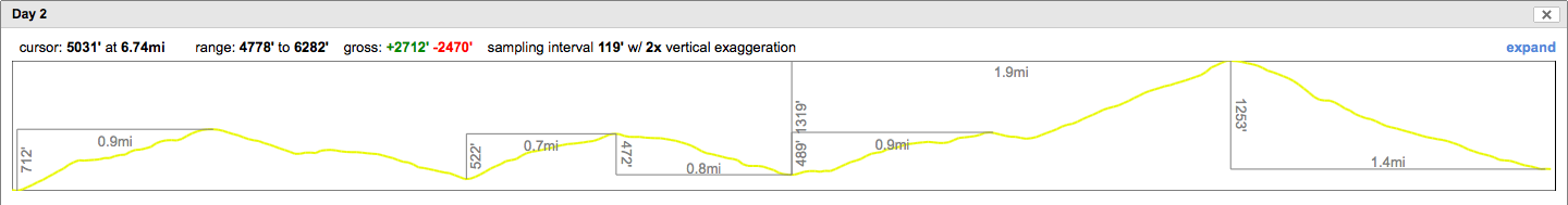
Day 2 has an elevation gain of 2712 feet (826m) and a loss of about the same coming in at 2470 feet (752m). This is all accomplished in a distance of 6.74 miles (10.8 Km).
Day 3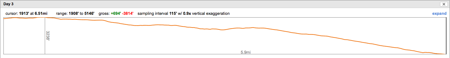
Day 3 is mostly a descent but has short sections of uphill. The route climbs 694 feet (211m) and descends 3814 feet (1162m ). This is accomplished in 6.51 miles (10.5 Km ).
So now comes my recommendations for training. First don’t stop what you are doing whether it be yoga, running, biking or classes at the local gym. Next try to add some walking/hiking. This doesn’t need to be long, even a mile or two is good but try to make it uphill and on trails. If you’d like, add some weight for the uphill but keep it light for the way down. Now that may sound a bit bizarre since what goes up must come down! What I would suggest is carry water, that way you’ll always have something to drink at the top then you can pour out the excess so that your pack is nearly empty for the way down. Your pack going up should mimic the weight you will be carrying on the trip, about 20-30 pounds (2.5 – 3.75 gallons). By emptying the water at the top you’ll get the workout the weight provides on the way up without the knee and back abuse going down with weight causes.
Try to get a longer hike in on the weekend, something that will prepare you for the longer days on the traverse. If you can get a couple of 3 to 5 mile hikes with 1500 feet or more of elevation gain that would be great. This will be a good way to explore the parks and forests near you.